|
 |
| click
above for larger map of Damaan area. |
 |
| click
above for larger view of locations of these projects. |
Damaan is the
floodplains region in the western central Pakistan. Gigantic hill-torrents
occasionally pouring down from its western Sulaiman Mountain Range
and finally joining the mighty Indus River in the east played vital
role in making its diverse geographies anddetermining its histories
and cultures.
Damaan was
once considered to be the gateway to India owing to its traversable
numerous mountain passes connecting Afghanistan and the central
Asia to the sub-continent. Invaders and traders continued to pass
through Damaan for centuries before the advent of new transportation
and communication technologies. Owing to its geo-political significance
and strategic location, Damaan turned to be a multi-ethnic and multi-cultural
region. Though Damaan is still predominantly Siraiki speaking region
but other major ethno-cultural groups include Balochs and Pakhtoons.
Damman is confronted
with the greatest challenge of its history: the challenge of mega
development irrigation projects imposing destruction on local livelihoods
and ecology, and violations of rights through very instruments oflaw
themselves. The government is implementing three mega irrigation
projects in the area including the Chashma Right Bank Irrigation
Project (CRBIP), Gomal Zam Dam Project (GZDP) and Kachhi Canal Project
(KCP).
ADB funded
Chashma Right Bank Irrigation Canal (CRBIP) is an extensive irrigation
project that involves the construction of a 274 km canal along the
Indus River and the construction of 72 distribution canals, 68 cross-drainage
structures and 91 bridges. The first two stages of the main canal
have already been completed, while the last and third stage is close
to its completion. Its total cultivable command area is approximately
606,000 acres of land. >>>Chashma
Irrigation Project.
Gomal River,
on which a 437 feet high Gomal Zam Dam will be built, is one of
the significant tributaries of Indus River. It is planned to irrigate
about 163,000 acres of land. The total projects costs amounts to
Rs. 12 billion. It will be a Roller compacted concrete dam, having
a gross storage of 1.14 MAF. It will produce 17.4 MW of electricity
when completed. Approximately Rs. 4.388 billion contracts for the
construction of Gomal Zam Dam Project was awarded to Messers CWHEC
- HPE, a joint venture of two Chinese firms in August 2002.
Kachhi Canal
Project was started in October 2002. The project, estimated to cost
Rs28 billion, is planned as a fast track part of Vision-2025, the
national development programme of water and hydropower resources.
The first leg of the project comprises 500-kilometre-long Kachhi
Canal to off take from Taunsa Barrage with a capacity of 6,000 cusecs.
According to the official documents, the project will provide irrigation
to 713,000 acres of land and will enhance cropping intensity in
the project area from the present 2 per cent to 46 per cent. The
Kachhi Canal will be fed through Taunsa Barrage for only six months.
>>>Kachhi Canal Project.
Development
Induced Destruction
|
 |
| Flooded
village in Riverine Belt. (6 April 2003) |
Notwithstanding
all three-mega irrigation development projects look fancy in terms
of tall claims to providing perennial irrigation water and magically
enhancing cropping intensity and yields and thus bringing prosperity
and well-being to people of Damaan, there is another and much ugly
side of the coin as well. Floodwater of traditional rowed-kohi system-
once cherished an important source as well as sustenance of life
supporting system- will be now wrecking havoc in one or another
form. As the gigantic structures of both CRBIP and KCP are located
in the middle of more than two hundred bigger and small natural
flood channels in the area, floodwater will be blocked and thus
create massive project induced flooding and displacement. Furthermore,
an unnatural blockage in the drainage of floodwater will multiply
the process of sediment deposition in the west side of these projects
and will be thus adversely impacting livelihoods, ecology and geographies
in the area. Legal and historical rights of local communities over
floodwater will not only be disrupted but a large number of the
people of Damaan will be permanently deprived to continuing the
use of floodwater.
In the case
of CRBIP, this threat of massive project induced flooding has already
become reality. About twenty-two villages in the west side of the
main canal and more than fifty villages in the Indus riverine belt
are facing project induced flooding and displacement. Approximately
fifty thousands acres of land is now seasonally submerged by blocked
floodwater in the west side. Consequently, local farmers are not
able to grow their crops, which are their only means of income and
livelihood. The level of the west side will continue to rise up
steadily because of high sediment deposition and will thereby not
only further create threats for human settlements but can pose a
grave danger to the safety of the main canal itself and other related
engineering structures.
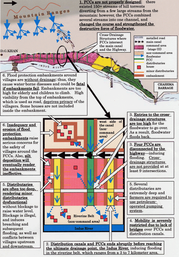
 |
| Click
above to view the illustrated summary of design failures and
subsequent damages of Chashma Project |
Local communities
of the Chashma project area living along the Indus riverine belt
are now teasingly sandwiched between the continuous riverbank erosion
and project-induced flooding. More than fifty villages are now not
able to grow seasonal cotton crops in the monsoon season and increasingly
becoming impoverished and vulnerable. Flooding and subsequent massive
sediment deposition is causing changes in river flow patterns. In
the case of KCP, the situation will not be different.
Gomal Zam Dam
Project will not only be creating up-stream inundation after the
construction of a 437 feet high dam and also a barrage in the downstream
but will permanently deprive more than fifty thousands of people
in southern part of the project area from their legal and historical
rights over floodwater. The area in this side will become desert
and people will be compelled to migration from their native living
places. The success of GZDP is highly susceptible because of
high sediment
deposition in the dam area. According to the official figures, about
750 million tones of silt will be annually deposited in the dam
area. See the Survey Report on Gomal Zam Dam Project.
All three mega
irrigation development projects are likely to further aggravate
inter-provincial conflicts around water and generate ethno-political
tensions in Damaan as well as at country level.
Land acquisition
process during the construction of CRBIP was not only totally illegal
and against the provisions of national laws but compensation rates
are much lower than the average market land prices in the area.
An emergency was imposed for the purpose of acquiring land from
farmers and majority of them have not yet been compensated. The
situation in the case of GZDP and KCP is no more different.
Though sudden
raptures in traditional lifestyle, disruptions in physical mobility
and breakdown of social networks and local markets links can not
be quantified on any terms but such happenings will have longing
adverse impacts.
|